Sunday, 28 April 2024

2023 Ben Nevis! (write-up a bit late)

 30 April 2023


Very late with this write-up but better late than never!

Ben Nevis the highest mountain in Scotland, the United Kingdom, and the British Isles. 

The summit is 1,345 metres (4,413 ft)[1] above sea level and is the highest land in any direction for 739 kilometres (459 miles). Ben Nevis stands at the western end of the Grampian Mountains in the Highland region of Lochaber, close to the town of Fort William.

The Easter treats provided in our lovely cottage to fuel us going up the hill!


 The easiest route up the mountain, the track begins at the Ben Nevis Visitor Centre car park, at Achintee on the east side of Glen Nevis about 2 km from the town centre of Fort William, and approximately 20 m above sea level. The track starts with a steep climb to the halfway lochan', or Lochan Meall an t-Suidhe, and then the ascent features snaking zig-zag paths up to the summit.


What you miss from the images is how windy it was! Very blustery indeed up here.


J fuelled by courtesy Iron-bru!


At the summit, there's a cairn that marks the highest point and your reward on a clear day there are incredible 360° panoramic vistas which can stretch as far as Northern Ireland. From the top, see if you can point out other peaks including the Torridon hills, Ben Lomond and Morven at Caithness.


A unique feature of the summit is the Old Observatory, which was opened in 1883. It provided hourly meteorological data for almost 20 years, recording some of the UK's most useful information about mountain weather to date. It closed in 1904 and it now lies in ruin, but can be used for shelter in emergencies.


A great walk. Kids found it a doddle. Adults however had sore knees the next day.


Sunday, 7 August 2022

Ben Chonȝie, The Boring Munro


 2nd June 2022

Ben Chonȝie, also known as Ben-y Hone (Gaelic Beinn a' Chòinnich, meaning 'mossy mountain'), is a Scottish mountain situated eleven kilometres northwest of Crieff. It stands at 931 m (3054 ft).


Start the walk from the parking area opposite the old school at Coishavachan up Glen Lednock (not the signed Old School 900m before the parking area). From here walk up the track towards the houses at Coishavachan. Turn right in front of the two low cottages and go through the gate and onto a rougher track. The track curves to the left and passes the buildings and gently climbs uphill.
Keep following the track and go over a bridge and through the gate. As the climb increases the views back improve and the route up the flank of Ben Chonzie can be seen. Pass the small dam on the Invergeldie Burn and climb up the other side. Where the track splits, keep on the main track to head uphill.
Rest stops - it was a hot day!


The track climbs more steeply and fords a stream. Keep straight ahead where a track leads off to the left and continue climbing. Before reaching the crest of the hill ahead, turn off the track onto a path on the left, at a sharp bend to the right, there is a small cairn marking the spot. The path is boggy to start with but then improves although it is indistinct in places. The route follows the easy, broad ridge, of heather and blaeberry plants, with grand views back over the glen.

Far from boring this was a great wildlife walk. We heard cuckoos, found a frog, saw two mountain hares (Lepus timidus) and butterflies etc.


heading out!


That sun!


Snack break!


Keep to the easiest ground. climbing steadily. Soon a line of metal fence posts is seen, these lead to the summit and are an excellent navigational aid in poor weather. Follow the fence posts when they turn NE at a right angle and head up the final slope to the summit at 931 metres and the large shelter just beyond. There are good views down Loch Turret. a butterfly at the summit!


A dog tag found on the descent and left on a cairn for the owner to find!


Ben Macdui and Cairngorm

 1st May 2022


Ben Macdui (Beinn Mac Duibh, meaning "Mac Duff's Hill") is the second-highest mountain in Scotland after Ben Nevis, and the highest in the Cairngorm Mountains.

Distance - 17.5km / 11 miles
Time - 6 - 8 hours
Ascent - 932m


Setting put on the ascent from the Coire Cas car park at the foot of Cairngorm Ski Centre by a path that leads up over slowly rising moorland. This route is about 7 km (4 mi) long.

he path continues across the moor and soon crosses the Allt Coire an t-Sneachda with the help of stepping stones. At the next fork beyond - with a much poorer path - again keep to the larger, lower path.


Cross the next stream, which issues from Coire an Lochain, and continue on the path up onto the wide ridge of Miadan Creag an Leth-choin. As height is gained great views open up on the left, across the gulf of Coire an Lochain - with its tiny lochan - to Cairn Lochan.


Continue across the stony tundra, rising gently before a slight descent and then a longer gradual and stony climb across the flanks of 
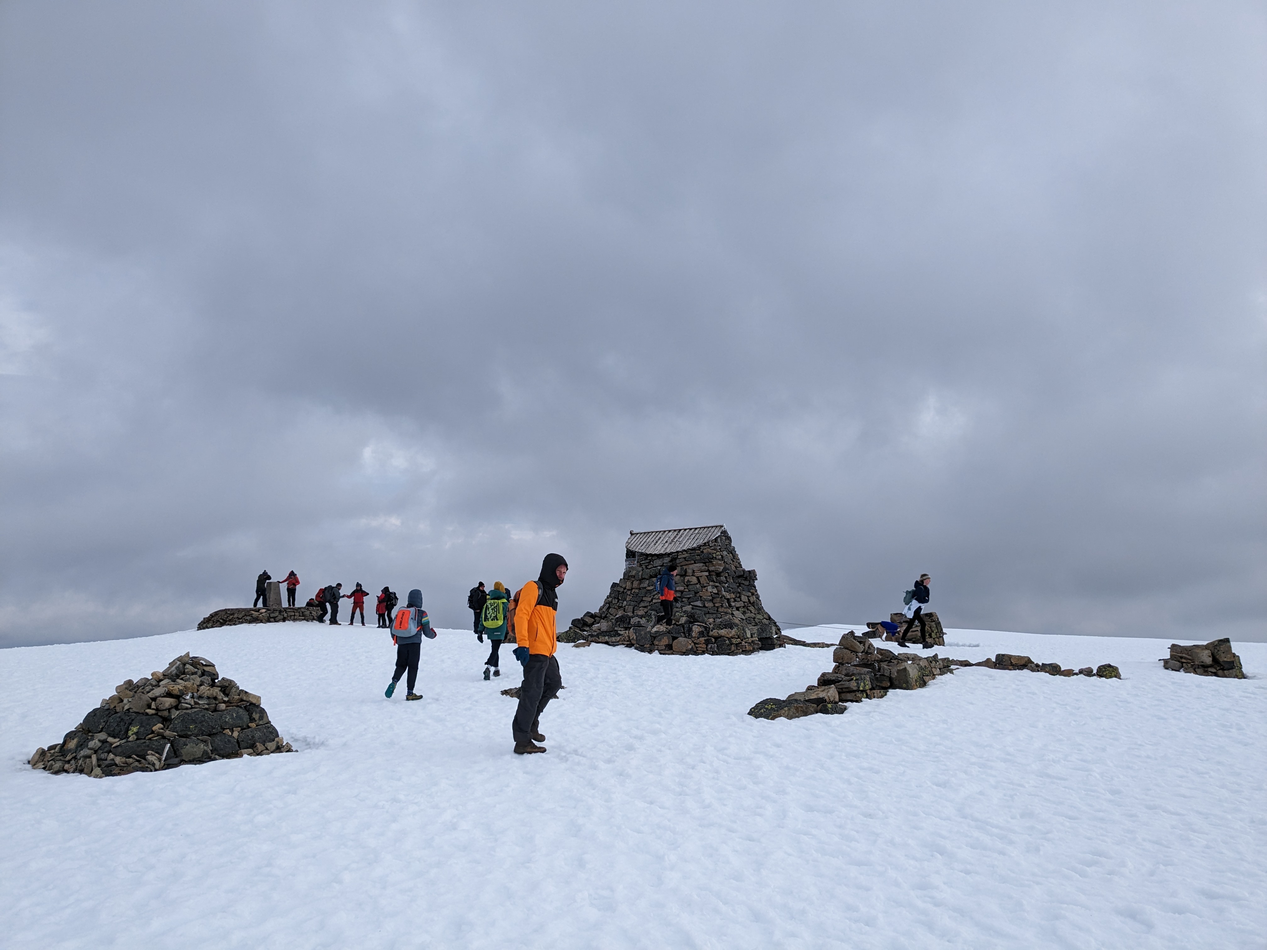
Ben Macdui's northern top to reach the true summit. Lots of snow and fog at this point.


The second highest mountain in Britain is marked by a massive cairn topped with a trig point. A view indicator helps to identify the many summits in view though the expansive plateau means the view lacks great depth. Return the same way but keep on the right hand path to pass closer to Lochan Buidhe. The area of Ben Macdui is said to be haunted by the legendary Am Fear Liath Mòr, or Greyman. There have been several accounts of an unnatural presence, with mountaineer Norman Collie claiming to have heard footsteps before fleeing from the summit in terror.... we did not see or hear anything untoward..

.... but it was a very chilly picnic...


The path crosses the slopes above the headwaters of the Feith Buidhe. In winter the terrain can seem quite featureless and the weather is often simply ferocious. The edge of the northern corries is reached at the bealach between Cairn Lochan and Stob Coire an t-Sneachda..


Continue to the right over Stob Coire an t-Sneachda with impressive views down the cliffs. We pressed on here to ascend the broad slopes to the east to reach the summit of Cairn Gorm. After passing through knee deep snow....


We all had to perch on a rock and empty our boots of water!


The views from here are much more dramatic than those from Ben Macdui, with grand views over the great carpet of Rothiemurchus Forest and the drama of the Northern Corries.

The summit of Cairngorm!


Queen Victoria hiked to the summit on 7 October 1859, aged forty. About her experience, she wrote: 'It had a sublime and solemn effect, so wild, so solitary – no one but ourselves and our little party there ... I had a little whisky and water, as the people declared pure water would be too chilling.'

 The summit of the mountain has a direction indicator erected in 1925 by the Cairngorm Club of Aberdeen in memory of former president Alexander Copland. The indicator shows the directions of the most noteworthy mountains that can be seen from the summit in clear weather.


Descend north to the Ptarmigan restaurant


Excellent  reading for our Cairngorm adventure!