Saturday, 4 June 2011

Ceapabhal hill and Toehead walk near Scarister, Harris.

Monday, 30th of May


Another walk during the Braxony tour of the Outer Hebrides. Following an inspection of the peat bog near our B & B and then a wander around the Church of St Clements at Rodel, we visited my Grandparents old house and their neighbours and then headed off to Scarister.

Just before reaching Scarister we turned off the road to Northton and parked. We then took a small track leading towards the peninsula of Toehead which is home to some of the most rare and precious machair grasslands and breeding birds in Britain today. By heading away from Scarister beach we reached the southwest side of the peninsular and then headed across flat ground towards the ruin of a 12th century chapel (Rudh'an Teampull) and remains of an ancient Broch.


After parking at Northton we headed over the machair to the temple trying not to disturb the birds - The Lapwings were however pretty flighty and flew pretty close over our heads.

Looking across the machair.


The chapel is situated in the shadow of Ceapabhal hill. It is medieval, (some say late, some early), and was built on the site of an Iron Age broch. The church was probably built re-using some of the same stones. It has a window in each of the four walls. The wall at the east end has two niches where religious vessels were kept. There are remains of a graveyard surrounding the ruined church. Nearby, archaeologists have found the remains of the oldest known settlement in the Outer Hebrides which dates back 9,000 years. Looking out over the Caolas na Hearadh, (Sound of Harris), you can see the island of Pabbay in the distance.

After looking around the ruins for a while we decided to walk around the peninsula, Toehead following the coast line. So we followed a faint path along the coast until we found a number of caves.

At this point the hill drops sharply into the sea and the cliffs begin to get so steep that there seemed to be no way of continuing around the coast.

So we headed straight up and over the top of Ceapabhal hill. The ground was pretty boggy and we met an inquisitive group of Highland cows.

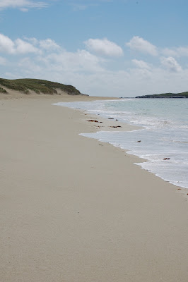
After heading straight over the top of the hill we came across gorgeous views of Scarister beach below on the northeast side of the peninsular.

B. above Scarister beach.

Looking back towards Northton.


We then headed straight down to the beach and came across large groups of Oystercatchers


Machair - incidentally the other Machair was a Scottish soap opera produced in the 1990's in which my uncle Iain acted!


Message?


Scarister


J. on Scarister

Huisinis, Isle of Harris

Sunday, 29th of May

The Braxony tour of the Outer Hebrides started in Lewis staying with uncle Iain. We had a fantastic couple of days in very exciting stormy weather. We then headed down to Harris which greeted us with beautiful beaches and sunny weather. We stayed at the most fantastic B & B I have ever come across: The Old School House, located in Finsbay, where we were treated to feasts of Tarransay venison and local wild muscles, which even contained pearls. A really wonderful place to stay and a foodies dream.....

After Harris we headed down to Berneray, N. Uist, Benbecula, S. Uist, Eriskay, Barra and returned to Oban via Tiree and Coll.

We had a few lovely walks on this trip a couple on Harris were particularly good so I thought I would include them on the blog.

On the way down from Lewis to North Harris just before Tarbert we turned off the A859 to the left onto the B887. A tiny, windy picturesque road which winds for about 15 miles to the western side of Harris, passing directly through the front garden of Amhuinnsuidhe Castle, (1864-7). The settlement of Huisinis consists of only four houses overlooking a white sand beach with views to the Atlantic. Nearby, and to the north, lies the uninhabited island of Scarp, the location of an experimental rocket postal service by the German rocket scientist Gerhard Zucker in the 1930s. The experiment apparently failed due to the inability to obtain the correct fuel. The rocket exploded on launch and the scattered and singed remains of the mail was subsequently collected by the Harris postmaster, marked that it had been "Damaged by explosion at Scarp, Harris", and delivered by more conventional means. ( singed envelopes from the exploded rocket can still be seen at the island museum).

After parking the car at Huisinis and admiring the beach there we headed off from just past the jetty, with a easy stroll across the grass. The path soon leads round the edge of the coast, climbing steeply over the hill, where hands are sometimes needed to scramble over the rocks. Once over the hill, the path flattens out again and eventually gets to the beach; one mile of the most beautiful sand and clear turquoise waters are found at the end of it. The beach was completely deserted and looks directly across the north end of the sandy, shallow and notoriously treacherous Caolas an Scarp (Sound of Scarp) which separates the island of Scarp from the mainland of Harris.


The path leading around the coast towards the beach.


The path heads over some fairly impressive cliffs, which makes ideal bird watching territory.

There were lots of cormorants fishing below us on the rocks.


Looking along the path towards the beach.

J. on the deserted beach

Looking across to the island of Scarp


Looking across to Scarp. Although the island is uninhabited some of the old buildings have been renovated as holiday homes.


Seal cloud?


oyster-catcher eggs


Starfish


Boulders at the North end of the beach


dead Gannet


Live gannet diving - (It's amazing how they just plunge into the sea, beak first at breakneck speed)


Old rope

Ben Cruachan & Stob Diamh

Friday, 3rd of June, 2011

Ben Cruachan - Stacked Hill - 1126m - Drochaid Ghlas - Grey Bridge - 1008m - Stob Diamh - Peak of the Stag - 998m - Stob Garbh - Rough Peak - 980m, (Ben Cruachan & Stob Diamh Munros)

Ben Cruachan is generally considered one of the finest Munro's in the southern Highlands, its pointed peak towers above rocky satellites giving really amazing views. The ridge walk to Stob Daimh makes a great circuit around the Cruachan reservoir - it really is a cracking walk!

We did this walk on our return journey from the Outer Hebrides - Having been subjected to mixed weather on the islands (hail in Lewis, sun in Harris and gales on the Uist's) we were rewarded with a stunning day after we spent the night in Oban. We had marked out a couple of walks in the Cruachan range but given that the weather was so perfect we went for the longest and most interesting walk. A super day.


View 2011-06-03 09:47 in a larger map

J. managed to track our route, which took just over six hours. The tracker says that the walk was 11 miles with a max elevation of 1558m, max speed 6.5 mph...


We started the walk by parking by the falls of Cruachan railway station. From the Railway Station sign we walked up the path and then under the railway in a low underpass, and climbed the concrete steps up the other side until a path on the left headed up through the trees, passing a wire fence. The path starts by meandering through oak, birch and hazel wood, climbing steeply in places. The Allt Cruachan can be heard flowing down the little gorge on the left. After the trees thin out, the path, with great views back over Loch Awe, continues up towards the Cruachan dam.


We then headed up to the dam and climbed a small near vertical ladder up onto the top of the dam itself before heading around the left hand side of the reservoir.


At the head of the reservoir we then branched off up a small track to the left and heading straight up towards the bealach below Ben Cruachan. The path climbs steeply following the rugged ground until Coire Dearg is reached. From here it is a short and steep pull up an eroded stony path to the bealach. There is a small lochan here.

After reaching the top of the bealach the path headed directly up to the summit of Ben Cruachan. Nearing the top the path gives way to a great expanse of boulders which gives some very entertaining climbing.


Looking back down towards the reservoir.


The final summit marked by a cairn and the stump of a former trig point. At 1126 metres this is the highest summit for miles around. The views are fantastic, particularly down over Loch Etive, and out to the west.


The weather was super so we really could see for miles. But it had made for a very hot climb and we were both pretty pink by the time we got to the top.


Views!


From here the route turns north east down a clear ridge which is pretty steep and rocky in places, seen behind B. at the summit of Cruachan.

J at the summit of Cruachan!

After the first dip, the route crosses a series of rock slabs, it looked as though these could be bypassed by heading downhill but as it was such a dry day we just headed over them being careful not to lose our footing. The ridge continues, stony in places, with wonderful views in all directions. The steep climb leads almost to the summit of Drochaid Ghlas, we made a short detour to reach the cairn marking the top, but this can be missed out.

Views!
Looking back along the ridge to Cruachan.

and looking further along the ridge towards Drochaid Ghlas.

Steep rocky slopes on the sides of the ridge.

On towards Stob Diamh. The ridge is a pleasant walk with a steep pull up to the summit of Stob Diamh, with great views back to the peaked summit of Ben Cruachan. At the Stob Daimh cairn - the second munro of the day - the clear horseshoe route from the Dalmally side can be seen.


Looking along the ridge.

J. at the Drochaid Ghlas cairn.

B. at the Drochaid Ghlas cairn.

J. at the Stob Daimh cairn - the second Munro of the day.

B. at the Stob Daimh cairn

From here we headed south along a clear ridge, crossing a bealach before the slight climb to Stob Garbh. After this the route descended easily to the bealach at the Lairig Torran where the route turns to the right and heads down the easier but boggier grassy slopes alongside a stream. As ever we missed the path going down and had to improvise a bit. It was a fairly tough downhill stretch - and we reached the car with pretty sore knees but was well worth it!


Nature spotting!

A prince?

Lunch: no luch on this walk but a full on egg / kipper/ porridge Oban breakfast!

New Kit: Have I mentioned J's shiny new orange walking top? .....