An Casteal, Beinn a Chroin & Beinn Chabhair - "The Castle", "Hill of Terror/ Hill of the Sheep Fold/ Hill of the Cloven Hoof", & "Hill of the Hawk/ Hill of the Antler" -995m, 942m & 933m - (All Munros)
An Casteal, Beinn a Chroin & Beinn Chabhair facts!
These three mountains are part of a group of seven Munros that stand to the eastern side of Glen Falloch.
Crianlarich means "Low Pass" in Gaelic. It bills itself as the gateway to the Highlands but then so do a number of Scottish towns. In the 1750's two military roads met here, one from Stirling , the other from Dumbarton. This pattern more or less continues today with the meeting of the A82 and the A85.
The West Highland Way or Slighe na Gàidhealtachd an Iar runs at the foot of these hills. It is a long-distance walking route from Milgavie to Fort William - (96 miles). The walk is typically done in 7-8 days, however once a year they hold a race to run the route. The current record holder is Jez Bragg from Solihul who ran it in 15 hours, 44 minutes and 50 seconds, in 2006.
Well, the weather forecast for today was touch and go, but we decided to push our luck and give it a go. The first hour and a half consisted of traipsing up an 80 degree bog in horizontal driving drizzle.....lovely! I am however pleased to say that the worst of this walk, both in terrain and weather, was over in the first hour, the rain soon abated, and after about three hours we were rewarded by lovely sunshine.
10 hours - 3 Munros ...a Braxony record :)
Braxony headed off on this walk unaccompanied. We left the car in a lay-by on the A82 and headed off across a field, crossed the railway line at the wrong place and had to negotiate our way across a river...needless to say we had wet feet before this walk even started.
We then joined a landrover track and followed this a little way toward the base of the first hill. Whilst planning this walk we had read that the sooner you head up onto higher ground the more bog you miss, so we headed off the track at the first opportunity and headed up the hill. I don't know what the ground would have been like if we had carried on a bit further but this route was pretty damn wet! an 80 degree uphill bog marvellous!
Still we pressed on passed some amused looking shorthorns ....

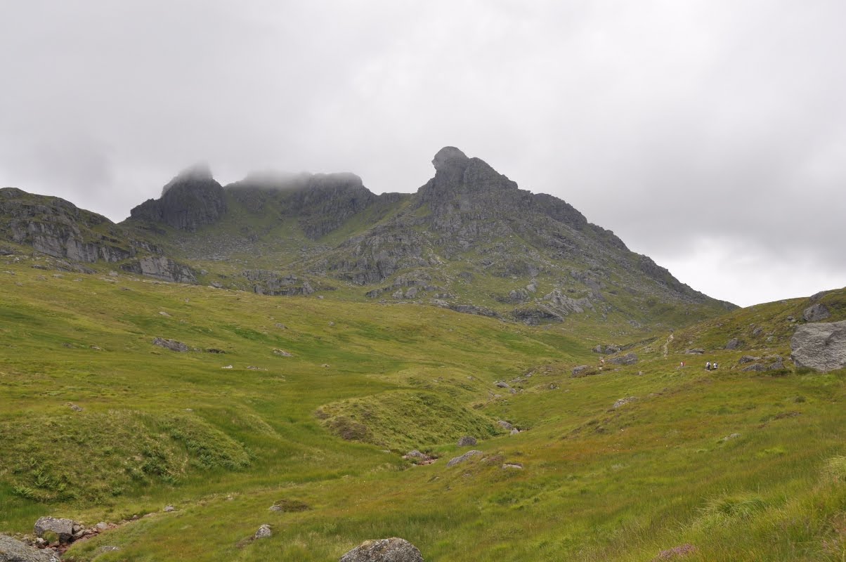
 ....we had about an hour of rain and some really strong winds as we undertook this ascent. We headed SSE up to the summit of Sron Garbh, approx 700m and began to get some pretty nice views back over the valley.
At this point we then joined a path along "Twistin Hill" ridge, which is far better underfoot and gives pretty good views over both sides.

It was then a pretty straight forward walk up to the summit of An Casteal, which as it turns out is rather aptly named and is indeed very rocky and castle-like. As photo's often fail to capture quite what the weather is like on a walk, (and I am worried that you may think that I am exaggerating ;) we took a few video snippets to illustrate:
Yay - Munro No. 1! (995m)

So we made it to the summit, still a little damp and very windswept! The views at this point were intermittent to say the least, but the weather was moving so fast we suspected that things might clear a little in time.
 Once at the top of An Casteal there was a clear path bearing SSE leading along a ridge towards Beinn a Chroin.

At this point we did at last get some sunshine and things began to look up. The scenery was absolutely spectacular. We followed the path to the end of the plateau on An Casteal and descended onto a col, Bealach Buidhe, from here we stopped to admire the valley below and the chasing clouds, (All footage is in real time):

At this point we at last found a rocky outcrop to cower behind and have some lunch.
 We then headed on bearing ENE to the summit of Beinn a' Chroin. There was a path that snaked around to the right of the hill. It was pretty steep and required a nice bit of scrambling.
 From the plateau on Beinn a Chroin looking back over An Casteal.
Beinn a Chroin, is a long plateau with several mini peaks on it, in our enthusiasm not to miss the true summit, (it is pretty hard to tell which is highest, we went to each summit in turn. You can't say we are not conscientious!
 Jackson and his gloves!
By this point the views were again pretty stunning. The cloud had formed a very strong thick line at just above mountain level.
 On top of the plateau there was a little lochan, the wind was so strong that it was literally just blowing the water of the top, so Jackson tried to capture this:
Yay Munro No. 2! (942m)

So we then had to now retrace our steps along the ridge of Beinn a Chroin and descend back down to Bealach Buidhe. We then headed off piste and made our own way, as the crow flies, directly towards Munro No. 3.

This is looking back towards An Casteal and Beinn a Chroin. By this point we were getting pretty high up on the other side of the valley. It must be said the old legs were aching by this point but it's amazing what they will do if you push them.

It is hard to convey how steep this climb was but at points it was a all hands and feet affair, some good scrambles.

Yay Munro No. 3! (933 m) - Bryony has an excellent quiff in this pic!
 So we reached the summit of Beinn Chabhair .....
and were greeted by a friendly wolf.....
 So it's all very well getting up all these mountains but where to go from here....so we followed a path towards the corbett, Meall nan Tarmachan, then realised that the path was taking us just further away, so we headed off down the gully to a stream called, Allt a'Chuillin. We followed this down, through a lot of very boggy land, climbed three gates and eventually hit the West Highland Way. We followed this for a good 1/2 an hour passed Derrydorach farm and then had to followed the road for a further 15 mins back to where we had left the car. Shattered but happy!
 Finally with feet so sore I could hardly drive, we stopped at the first place we passed in Caianlarich that looked like it offered food, The Rod and Reel and had some hearty pub-grub - not amazing but certainly helped give me the strength to drive home!

Nature curiosities:
A dead mouse at the summit of An Casteal, a live one spotted on the way down.
Masses of Bog-Myrtle, (Myrica gale), which smells gorgeous when you rub the leaves and keeps the Midge's away. Also known as Sweet Gale or Gold Withy, it thrives in the boggier areas of Scotland. It was believed to give the cows who ate it peculiar flavoured milk. (Flora Britanica 70-71)
It also is perhaps responsible for the idea of Asterix and Obelix's secret potion:
It was apparently well known to the Vikings, who used to drink a brew before going into battle to induce a kind of berserk frenzy. They believed that it was the brew gave them extra strength and the battle recklessness, it's perhaps more likely it was certain other substances they took that caused this bonkers mental state. The leaves were often used in olden times in Scottish cooking, and you can still find restaurants that prepare fish and chicken dishes when it's young and in season, though its culinary uses are now generally quite rare. In fact there is little bog myrtle doesn't seem able to do!

New Kit:
None - (but look at J in his lovely gloves!)
Lunch:
Back to the bog-standard sandwich of ham and salad.
Excellent energy snack - Food doctor's herb seeds - top marks!
Apples
Chocolate
Orange juice